Пока работа над предыдущим материалом продолжается, мы не будем останавливаться и в этот раз посмотрим и почитаем про несколько самых крупных вулканов Коста-Рики (каждая фотография - ссылка на видео, либо большое фото).
оставшуюся часть переведу позже
Вулкан ПОАС
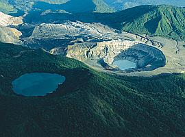
Расположен в 37 километрах от Сан-Хосе. Вулкан превышает 2700 метров по высоте. Это один из самых впечатляющих вулканов Коста-Рики. Земля в этом секторе очень плодородна, а также эта зона обладает значительным потенциалом для производства гидро- и геотермической электроэнергии. Первый из двух кратеров - 300 м в глубину и более 1 км в диаметре, второй (результат последнего извержения), наполнен дождевой водой. С платформы наблюдения можно видеть облака пара и курящиеся дымки от кипящего озера, расположенного в главном кратере, уровень воды в котором постоянно меняется в зависимости от активности вулкана. Живописные виды, открывающиеся на Центральное плато, оставляют незабываемое впечатление. Сочные по цветовой гамме склоны вулкана покрыты невысоким тропическим лесом. В таких лесах больше всего колибри и орхидей. Здесь живут большие черные дрозды и серые горные белки, можно увидеть и броненосцев, только на первый взгляд, кажущихся неуклюжими.
Вулкан ИРАСУ
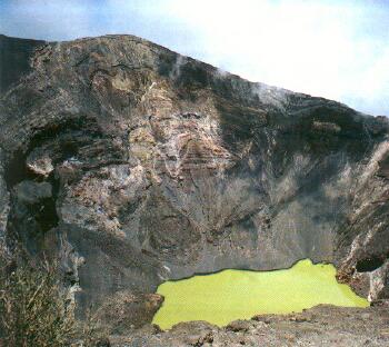
Расположен в 54 км от Сан-Хосе. Ирасу, или «природная пороховая бочка», как его называют, - это активный вулкан, достигающий высоты 3435 метров над уровнем моря (самый высокий вулкан страны) и занимающий территории приблизительно 500 км².
С вершины в ясный день можно увидеть с одной стороны Тихий океан, а с другой - Карибское море. Особенно впечатляющей является картина главного кратера вулкана с его искрящимся зеленым озером и крутыми отвесными стенами из лавы и пепла.
Извержение этого вулкана в 1723 полностью уничтожило столицу того времени - город Картаго.
Вулкан АРЕНАЛЬ

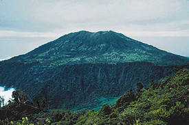
Национальный парк Ареналь расположен в 180 км от Сан-Хосе. Этот парк знаменит впечатляющим и величественным вулканом Ареналь, представляющий собой практически идеальный конус высотой 1633 метров, чьи постоянные извержения предлагают одно из самых экстраординарных и впечатляющих природных зрелищ в Коста-Рике. Начиная с 1968 года, вулкан Ареналь постоянно выделяет небольшие порции лавы и каждый год подрастает на 20 футов. Днем слышится глухой шум и частые взрывы, этого вполне достаточно, чтобы представить себе разрушительную силу вулкана-гиганта, скрывающуюся под тонкой земной оболочкой. Вершина Ареналя скрыта в облаках, но глядя на склоны, можно отчетливо видеть курящие дымки. За последнее время в парке появились отели с прекрасным уровнем обслуживания, лучшими видами на вулкан и соседнее озеро, у которого по утрам собираются одни из самых красивых птиц в Коста-Рике – танагры и туканы. Тем, кому не терпится быть непосредственно у вулкана, могут отправиться к вулкану Чато - в 3 км к югу от Ареналя. Чато спит под озером, по которому можно покататься на катере и насладиться прекрасными окрестными видами.
Вулкан ТУРРИАЛЬБА
It`s the most easterntip volcanoe of the Cordillera Central (the second volcanoe in the country in respect of metres above sea level-3.339). It has been active since 6.300 BC. In colonial times that was nicknamed by Spaniards as Torre Alba "white tower", because of its eruptions gave the impression of a huge white tower. It has three craters. To the main of them doesn`t lead any way. The catastrophic eruptions happened also in 1723, 1847, 1853, 1855 and 1861. Now the scientists claim its new eruption might be expected.
In March 2001 around volcanoe was felt some tremours and shakes. Many residents of the nearby area were afraid that it is the new cycle of activity, but the scientists claimed the shakes had nothing to do with that.
Вулкан ПЛАТАНАР

>(2.183 m.a.s.l.). A volcanic peak lied at the northernmost end of Cordillera Central, 7 kilometres south-east of the town of Quesada. It belongs to Juan Castro Blanco National Park.
There is no clear evidences of uruptive activity of that peak, but the thin layers of ashes covering in the eastern slope testified its activity within last few centuries. On its northern slope, flow the thermal springs.
Вулкан БАРВА

(2.906 m.a.s.l.). The oldest Costa Rica volcano. It`s within the boundary of Braulio Carillo National Park. Since 1492 is considered to be dormant. Its calderic structure make the eastern wall of Meseta Central. Two main craters are filled by lakes with clear and cold water. (Barva Lake-700 m. of width and Danta Lake-500 m. of width). Its slopes are dotted with coffee seedlings and covered with cypress and pines tree forests. It`s the only place in the world where lives where lives a toad Bufo Holdridge. (It`s inhabited also by Toad Harlequin).
Вулкан КАКАО

(1659 m.a.s.l.). It`s placed in the Cordillera Guanacaste range. It has an open crater towards the south-west of which there is no recorded activity. On its steep slopes, numerous streams and rivers are born that flow into lake Nicaragua and the Nicoya Gulf as in the case of Tempisgue river. On its slope, at an elevation 1.050 m.a.s.l. there is a Cacao Biological Station. It stands out also with a large number of petroglyphs.
Вулкан КАЧО НЕГРО

(2.136 m.a.s.l.). Extinct volcano that is situated in the central part of Braulio Carillo National Park. It`s known for its perfect conical shape. Its slopes are covered with cypress and pine forests. Around abound the cattle farms.
Вулкан ЧАТО

Its name means "the flat hill". Its the volcanic formation with collapsed crater and with the idyllic lake within that (it`s possible to canoe on that). On August 2000 there was the plane crash, where 10 people have been killed. Another plane hit its slope on January 2001. One pilot died.
Вулкан ОРОСИ
(1.487 m.a.s.l.). The legent has it that in the past on the top of volcano climbed the Indian military groupe. There they were spotted by an earthquake. One of them was expected to screamed that it`s a sign for silver presence. From the depths of the volcano came a powerful, echoing voice replying, "Plata, no; oro, si." ("Silver no, Gold Yes."). It`s crater is covered by forests. The first study of this volcano was made by Carlos Sapper in 1899.
Вулкан ТЕНОРИО

(1.916 m.a.s.l.) It`s in Guanacaste province. It`s the easternmost volcan of Cordillera Guanacaste.
It consists of four volcanic peaks and two twin-craters (sometimes called as separate volcan of Montezuma). It`s covered with savannah, rain forest at midelevation and above by clouds forests. From the western slope of Tenorio flows down the Tenorio river and from the southern slope rivers Tenorito and Martirio. From its top spreads the sight for Guatuso and San Carlos lowlands, Lake Nicaragua, Cano Negro National Reserve and Arenal Lake. From its slopes snakes down the Rio Frio. A legend exists of an eruption in 1816, but the volcano was observed to be densely forested in 1864 and is not considered to have erupted in historical time. Since 1989 it has been under a pre-feasibility study to determine its geothermal potential. In 1998 the vicinity of the volcano was hit by the 1 R scale earthquake.
Since 1995 the volcan is within Volcan Tenorio National Park. It`s known among others for the hot springs (with the temperatures up to 94 C) and bumbling holes. At the foot of Tenorio spread the plantations of macadamia.
Вулкан МИРАВАЛЛЕС

(2.028 m.a.s.l.). It`s situated 15 kilometres off Bagaces, (the highest in Cordillera Guanacaste). It contains 5 cones along a North-East trending line. The only reported historical eruptive activity was a small steam explosion in 1946. On its slopes a few mud bumbling pots and thermal springs. On the volcanoe foot there is Costa Rica`s Electricity Institute geothermal project. In the middle of XIX century there was a trial of organizing German colonization. On cloudless days, from the top it`s possible to see Nicaragua Lake.
Вулкан РИНКОН ДЕ ЛА ВЬЕХА

t was appeared about millions years ago. It means "the corner of old lady" and is attributed to indigenous people of the Guatuso tribe living on the eastern side of the volcano who believed that an old witch lived on top of the mountain and would send columns of smoke into the air whenever she got annoyed.
It has 9 craters (Rincon - 1.806 m.a.s.l., Von Seebach - 1.895 m.a.s.l., Santa Maria - 1.916 m.a.s.l.) and is considered as the third in respesct of activity volcanoe in Costa Rica. (Santa Maria crater is considered to be by some people as the separate volcano). It`s main crater has elipse shape, 500 metres of width and 100 metres of depth. On its bottom there is a hole with bumbling 250 Ceisius lava. In April 2000 the Canadian tourist has fallen to there for three days. To the east of crater there us a lake, waterfalls and bubling holes. In the terrain called Las Hornillas , the fumaroles hiss like kettles spitting up odiferous steam and gases. The last vital eruptions took place in 1966-1970. They were accompanied by clouds of ashes, earthquakes and tremors. The lighter eruptions took part in 1984, 1891 and 1996.
Ну и финальное видео: http://www.youtube.com/watch?v=CZwOs9Oj2B0 |
 ).
).


